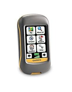
 The Garmin Dakota 10 is a tough GPS unit that’s a perfect companion during outdoor activities involving a lot of exposure to heat, rain and water. Its small form factor, measuring just 2.2 x 3.9 x 1.3 inches, and light weight (5.25 ounces) makes it both pocketable and easily mountable on a bike’s handlebar. This unit looks like a scaled-down version of Garmin’s popular Oregon models and, with its 2.6 inch touch screen, seems very likely to replace the eTrex line of GPS units from the same company. Priced at around $369 (much lower if you look around), this is an entry-level to mid-range device which has some notable premium features.
Features
Equipped with the company’s GPS HotFix, the device’s sensitive receiver and antenna are capable of noticeably quicker signal acquisition (about 14 seconds based on one outdoor test). There are worldwide base maps that come preloaded with the Garmin Dakota 10, but these may prove inadequate if the unit is to be taken “where no man has gone before”. An internal memory of 850mb is still plenty, so downloading and saving additional maps won’t be much of a problem. This unit will take a lot of freely downloadable topo maps and is compatible with Garmin’s very accurate BirdsEye Satellite Imagery system (however, this requires an annual subscription).
Taking a GPS with a high-resolution, back-lit display outdoors has always presented a problem, as these are normally washed out by direct sunlight. But Garmin R&D guys seem to be making inroads towards solving this as the unit has a display that is readable both outdoors and when inside a car. The battery life is also a plus on this unit, with 2000mAh rechargeable NiMH batteries lasting a little under 20 hours with the back light off.
Out of the box, the Garmin Dakota 10 has an interface that is intuitive, with a menu system that looks uncluttered. It’s also easy to personalize the menu arrangement and to create different device profiles, while both the compass and trip computer can be configured to show less and thus larger fields. This unit also has better than average waypoint, track and route management tools. For example, a route can be viewed, edited then reversed and made to display elevation data. Geocaching is also fully supported, though again, a premium membership to the service is required.
Cons
While definitely a topnotch performer, the Garmin Dakota 10 is not without shortcomings. What may turn off most potential users is the small touch screen area which could be cumbersome when accessed with clumsy or heavily gloved hands. This same inadequacy in screen size is also noticeable as less map detail can be displayed so you’ll be forced to zoom in and out more often as a result. Another concern is the unit’s cost. Despite its being competitively priced, some of the functions that set it aside from the rest require additional expenses, like more maps and service subscriptions.
Conclusion
As a basic unit, it does its job well, and its list of features and functions make it a unit that’s worth some serious consideration for outdoor applications.

